The National Hurricane Center NHC has upgraded Leslie to hurricane status this afternoon. From the satellite presentation and Oceansat-2 winds I think this is a prudent assesment of the strength in the core of Leslie.
On the wider view of the Oceansat data we see a very good circulation that is tilted eastward with the strongest winds over the northeast quadrant. Unfortunately NOAA and the Air Force Hurricane Hunter Aircraft are not flying into the storm. NASA is sending a Global Hawk over the storm tomorrow which may reveal the upper flow patterns and more about the tilt of Leslie, providing additional information for the models. This could help to pin down the track even more. A closer view of the Oceansat data (below) shows 65 knots from satellite derived winds near the center of circulation just northeast of the center.
The visible satellite view shows a slightly better organization to the storm today.
The track has shifted to the east as mentioned above, although possibly due more to the upper low northeast of Bermuda than the trough moving across the New England Coast.
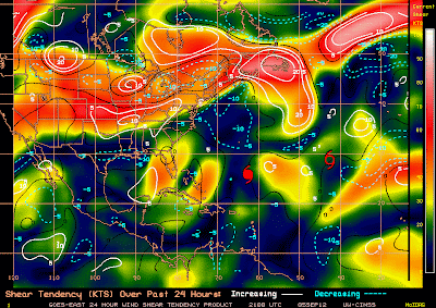
There is some developing wind shear to the west of Bermuda with a COL region (region of little winds and wind shear) to the north of Bermuda.
While the change in track isn't great news for Bermuda, it is better news. If the track continues the shift to the right I would expect the impacts will be less due to the stronger winds in eastern semicircle. Everyone I know, not many, in Bermuda are prepared and waiting.
Be Safe!
BC


No comments:
Post a Comment