Wednesday, October 26, 2011

Good evening all,

As suspected last night the shear is putting a hurtin' on Rina. The satellite presentation as deteriorated through the day and the northern semicircle of the system is being convectively subdued. The model tracks and intensity are in better agreement at least for the first 48 to 60 hours with a very slow moving system.
The  last update from the National Hurricane Center kept the intensity at 75 knots but mentioned that this is likely a generous value. The shear is tilting the storm toward the northeast and dropsondes are falling outside the low level eye which is providing errors in the surface wind and pressure extrapolations.


The satellite image with the overlay of the consensus/ensemble and dynamical model tracks above shows the lack of deep convection in the northern semicircle, and a banded feature between Jamaica and the western tip of Cuba.


Above is the National Hurricane Center official track with warnings and watches.
About 40% of the commercial marine traffic flows through the Florida Straits and Yucatan Channel heading for the Panama Canal. The image below show observations from land based, buoy based, and ship based instruments relative to the storm. Not many high wind obs in the grouping which would indicate that the storm wind radii may be very small.


All this boils down to several important things. Rina is likely to become a tropical storm,  then a depression very quickly, much more quickly than the hurricane center products are showing at this time. NHC has mentioned this in the last few discussions and calls. Fantasy Fest activities will have to contend with some rainfall Friday and Saturday but not a tropical cyclone, and I'm getting off the Rock for the FSU vs NC State game after all.

Cheers,
BC

Tuesday, October 25, 2011

Good evening/morning,
Rina had a very good day development wise. The storm had a burst of convection with an eye wall formation early in the day then intensified into a strong category two hurricane with sustained winds of 95 knots...109 mph...and gusts to near 115 knots...132 mph. The motion of the storm is still in question with the aircraft projecting a westward motion at 3 knots which is so slow that this could just be drifting. With the storm meandering expect that a concise model solution will be very difficult. With that in mind believe that the latest NHC Official forecast track is as good as its going to get unless the storm decides to start moving.


Some of the dynamical and ensemble member forecasts are shown in the image above from CIMSS. These tracks are shifting slightly with each run of the models with the official track sitting about dead center. The intensity forecast is most in question as the storm is not moving and is over some deep water. this long lived storm over nearly the same location for the past 3 days has to be inducing up-welling and mixing of surface water and exchanging it with the cooler water below 10 meters. The shear is slightly lower tonight than the past few days but still substantial to the north of the system. The satellite presentation of the system tonight has shown some stretching of the storm along an axis oriented from southwest to northeast. There are two dry slots set along the northwest and southeast sectors of the system which appear to be knocking down the outflow channel a bit as well. What this could be is the shear is taking effect on the storm, while the cutting off of the outflow would be an indication of some filling in of the pressure field...rising pressures in the storm environment. Both of these are detrimental to the future of Rina. The only caveat to this is that this could also be just a part of the diurnal cycle of convection in an intensifying storm. We will know by sunrise as the convection will usually burst up over night. The good news is that the storm should remain south of the Keys and be a tropical storm at best by day 5. The bad news is that NHC has issued warnings from Cancun to Punta Gruesa on the eastern coast of the Yucatan Peninsula, with tropical storm warnings from Punta Gruesa to Chetumal, with a tropical storm watch from Chetumal to Belize City.

Monday, October 24, 2011

Rina is a category one hurricane tonight and expected to increase in intensity to a category two to three over the next 36 to 48 hours. The forecast is still a bit uncertain as for intensity but this is reasonable.
The track forecast is settling down a bit with the HWRF and GFDL as the outlying models. All of the other guidance with the exception of the UKMET office keeps the system meandering around the western tip of Cuba and the Yucatan Peninsula.


The environment around this storm remains quite hostile for Rina if it moves much to the north. There is 20 knots of shear just north and this increases to near 60 knots over the Florida Straits near Key West. My thinking is that the storm will continue to meander for the next few days while it moves slightly northward over water with high hurricane heat potential, providing the catalyst for the intensification. Then as NHC stated, interactions with the Yucatan and the shearing aloft expect Rina to weaken before it is picked up by a trough moving across the eastern Gulf of Mexico by day 5.

                                      Shear graphic
Keep in mind that the run to run consistency in the models is not good, so the model solutions are in question. This is usually the case with slow moving storms.
More tomorrow,
BillyC

Sunday, October 23, 2011

Good evening all,

The area of disturbed weather in the western Caribbean has finally developed a low level circulation. The latest Air Force Hurricane Hunter aircraft found a low level center and NHC has issued the first advisory on TD-18. The last Vortex message from the recon aircraft was:

URNT12 KNHC 232100
VORTEX DATA MESSAGE   AL962011
A. 23/20:38:20Z
B. 15 deg 39 min N
  081 deg 52 min W
C. NA
D. 17 kt
E. 090 deg 0 nm
F. 160 deg 12 kt
G. 093 deg 15 nm
H. EXTRAP 1008 mb
I. 25 C / 211 m
J. 25 C / 212 m
K. 23 C / NA
L. NA
M. NA
N. 35 / 1
O. 0.02 / 10 nm
P. AF306 01KKA INVEST             OB 14
MAX FL WIND 12 KT E QUAD 20:33:00Z
MAX OUTBOUND FL WIND 31 KT SW QUAD 20:54:00Z
SLP EXTRAP FROM BELOW 1500 FT

The decode information is as follows:
Product: Air Force Vortex Message (URNT12 KNHC) 
Transmitted: 23rd day of the month at 21:00Z 
Aircraft: Air Force Aircraft (Last 3 digits of the tail number are 306) 
Mission Purpose: Investigate tenth suspect area (flight in the North Atlantic basin) 
Mission Number: 1
Observation Number: 14 
A. Time of Center Fix: 23rd day of the month at 20:38:20Z 
B. Center Fix Coordinates: 15°39'N 81°52'W (15.65N 81.8667W)  
B. Center Fix Location: 255 miles (410 km) to the S (187°) from George Town, Cayman Islands (GBR). 
C. Minimum Height at Standard Level: Not Available 
D. Estimated (by SFMR or visually) Maximum Surface Wind: 17kts (~ 19.6mph) 
E. Location of the Estimated Maximum Surface Wind: 0 nautical miles (0 statute miles) to the E (90°) of center fix
F. Maximum Flight Level Wind Inbound: From 160° at 12kts (From the SSE at ~ 13.8mph) 
G. Location of Maximum Flight Level Wind Inbound: 15 nautical miles (17 statute miles) to the E (93°) of center fix
H. Minimum Sea Level Pressure: 1008mb (29.77 inHg) - Extrapolated 
I. Maximum Flight Level Temp & Pressure Altitude Outside Eye: 25°C (77°F) at a pressure alt. of 211m (692ft) 
J. Maximum Flight Level Temp & Pressure Altitude Inside Eye: 25°C (77°F) at a pressure alt. of 212m (696ft) 
K. Dewpoint Temp (collected at same location as temp inside eye): 23°C (73°F) 
K. Sea Surface Temp (collected at same location as temp inside eye): Not Available
L. Eye Character: Not Available 
M. Eye Shape: Not Available 
O. Navigation Fix Accuracy: 0.02 nautical miles 
O. Meteorological Accuracy: 10 nautical miles 
Remarks Section:
Maximum Flight Level Wind: 12kts (~ 13.8mph) in the east quadrant at 20:33:00Z
Maximum Flight Level Wind Outbound: 31kts (~ 35.7mph) in the southwest quadrant at 20:54:00Z 
Sea Level Pressure Extrapolation From: Below 1,500 feet

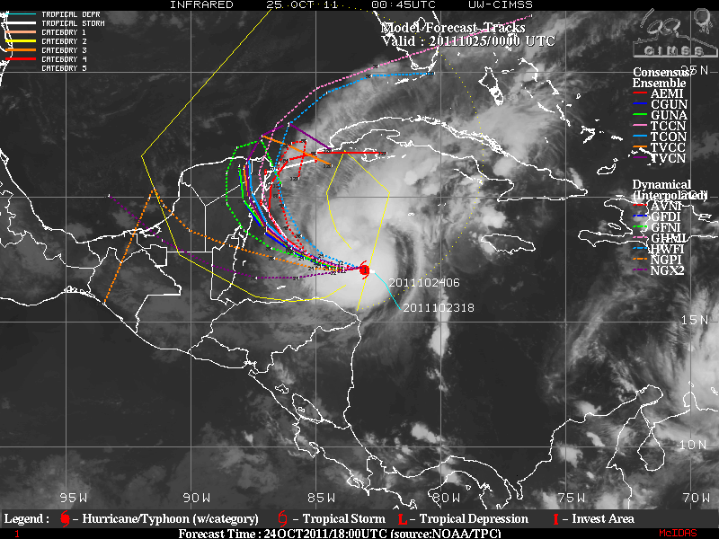
The maximum sustained winds are near 30 knots and it is expected that the storm will strengthen and become tropical storm Rina within the next day or so. 
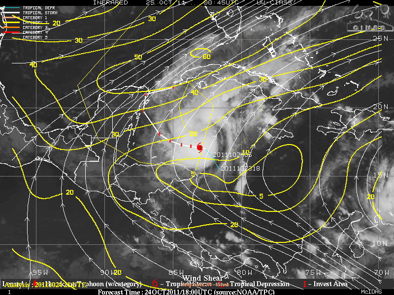
Steering flow is very weak and upper level shear to the north is increasing from around 40 knots to near 60 knots over the southern Gulf of Mexico. 
The forecast solutions are a bit diverse in the current runs as they have the storm in slightly different locations across the western Caribbean to the western tip of Cuba before it gets sheared apart. Below is the National Hurricane Center forecast points which has split the difference in the forecast points from the GFS and the ECMWF. 


So the main area of concern will include the Gulf of Honduras which our friends Delfina and Mitch Mitchell live on an island off the coast of Belize. 

The only forecast issue for south Florida and the Keys will be potential for rain. The further north the system drifts, the more likely we will have a rainfall event, hopefully not similar to last week. So we wait for  a few more model runs with the initialized circulation dropped into the algorithm to have a more cohesive result.

BillyC 

Saturday, October 22, 2011

Whew...we are standing down from the projected assault that has been in the global models
for the past 3 days. The system is drifting northward into a less favorable environment.
So I'm sorry if I put undo stress out there but after last week and the evolution of the model
forecasts, Just about everyone in south Florida was a little worried.
Looks like I'll get to go to the NC State game after all. :-)

Friday, October 21, 2011

Maybe I was a little premature in my thoughts about the demise of the hurricane potential for the
rest of the season. There is an area of low pressure brewing on the tail end of the decaying front
over the western Caribbean. The shearing environment if favorable for development and a look
at the MIMIC Satellite Derived Tropical Precipitable Water products from CIMSS we find
ample moisture.
http://tropic.ssec.wisc.edu/real-time/mimic-tpw/natl/main.html

The low is still disorganized but the conditions are getting better. A look at the Infrared imagery
shows the suspect area.


Pressure is falling across this area and from the surface observations plotted on the image above
we see a large circulation forming.
The 5 day Hovmoller diagram show the evolution thus far and how this is a persistent pattern
remaining nearly stationary between the Panama Bite and eastern tip of Nicaragua.


As for what this will become? The global models are in good agreement for the early stage of the
storm life cycle, and similar there after. The latest GFS prognosis is to bring the storm north across
the western tip of Cuba, then drive it east through the Florida Straits. The ECMWF has the system
in the same place off western Cuba but then differs by taking it north across the Sarasota/Tampa
area, continuing off the Daytona to Jacksonville coast. The Canadian (CMC) takes the storm to
the western tip of Cuba before the run ends. All of these are similar through 132 to 144 hours. 
That all the models are developing a storm is the issue. Normally I would be stating the fact that
there is yet to be a circulation initialized for the models to bite onto. However, when all of them
starts a storm it is a good bet there will be one. So we will wait to see what we get when the initial
circulation is plugged into the existing solution. I expect that my trip to Tallahassee for the NC State
game will be nixed due to demands of operations here. I will keep the blog updated but these may
be brief if we get into watches and warnings.
The current intensity output shows a possibility for a category 3 to 4 storm and it would be named
Rina.
Expect if the storm develops hurricane operations will begin as early as Tuesday night for the Keys.

Thursday, October 20, 2011

Fall has arrived in south Florida finally. Not a moment too soon. Key West is still recovering from the
flooding rains from earlier in the week. Fortunately the Goombay Festival will have great weather for
the weekend. We currently have dew points in the 50s at the southern most point of the contiguous United States. As for the rest of the country, there are only a few regions with any precipitation, mainly the Great Lakes and New England, with some show/rain depending on altitude in the northern Rockies. The returns in the southeast are false returns noot rain.

Select to go to the NWS homepageDoppler Radar National Mosaic

NHC is watching a couple of areas in the Atlantic but will say that the trough in the east will keep any
thing tropical away from the US coastline at least through 10 days at this point.

Cheers,
Bill

Tuesday, October 18, 2011

A tornado watch is effect for south Florida until 10 pm and will likely be extended through 2 am tonight.
We've had some interesting squall line propagation across the Keys this evening and had to issue a few Special Weather Advisories, many Marine Warnings, and a Flood Watch for the Keys. The Flood Watch is particularly interesting in that Key West has had over 11 inches of rain, with several stations reporting between 12 and 15 inches over the past 3 days. There was 3 feet of water inside Harpoon Harry's and most of the west end of the Island was impassable.
Will post some pictures when I can upload them.
The front heading toward the southeastern Gulf of Mexico has a very good chance to be the end of wet season and mark the last chance for tropical development in the Gulf.

Cheers,
BC

Monday, October 17, 2011

Good evening,

What a difference in the last 8 hours. This morning I would have bet the farm that NHC would name
invest 95L this afternoon. Air Force hurricane  hunters found no surface circulation in the suspect area north of the western tip of Cuba. That is great news...but...the mid level circulation is trapped in the southern Gulf of Mexico and will begin to be influenced by a vigorous trough crossing the northern Gulf Coast during the next 72 hours. The trough will take the mid level feature northeastward toward the Bug Bend of Florida. No tropical characteristics will be associated with the system but there is plentiful moisture available as evidence by the record breaking rainfall amounts over the Lower Keys during the past 24 hours. The previous record occurred in 1910 as the category 3 to 4 hurricane of October 17 passed just west of Key West producing 4.08 inches of rainfall. There has been 6.55 inches since midnight and more expected. With this in mind expect that there will be another couple of days of rainy conditions across Florida similar to last week with small craft advisory conditions spread across the coastal waters surrounding the Florida Peninsula. The following animation shows the evolution of the forecast through 96 hours.


Sorry I haven't posted during the last few days, the last 3 mid-nights have been a little rough, last night was a very long night. Check out the products from www.srh.noaa.gov/key warning products from overnight.
Stay tuned,
Bill

Thursday, October 13, 2011

A trough will head eastward across the eastern United States Friday with a ridge of high pressure building over the Deep South Friday night and Saturday. The trough and associated surface boundary will be much drier than the system last weekend, and have a much more subdued impact. The surface ridge will cover most of the southern tier states through Monday while a developing low in the western Caribbean Sea slides northwestward. Winds will freshen across the southern extent of the ridge between the high and the Caribbean low. The location of the ridge will likely keep Indian Summer conditions going through Tuesday across the southern United States.

There is still much debate about the upper low from last weekend that has the science community at odds with the media. The surface feature that developed was much weaker than the upper low that produced the MCV over central Florida, and the winds along mainly the east coast of Florida, extending northward to the Outer Banks. All the features of the system were over land and had little tropical characteristics but the folks on that channel I "love so much" not, but the Weather Service and Hurricane Center in an uncomfortable position. The local WFO's were handling the event very well and advertised the impacts for up to 6 days ahead in some cases.  I tried to down play the impacts as far as the tropical development goes as did the WFO's and NHC. We kept looking at the flooding potential and at strong wind fields which is exactly what the effects were.
Several questions for the viewers again...
Would you have paid more attention to the weather if there was a named storm?
Would you have done anything different to prepare if the system was name as a tropical storm?
Is there anything I can do better to inform you with the possibility of a similar event in the future?
Please send comments to billycott@gmail.com

Thanks and have a great weekend,
Bill

Sunday, October 9, 2011

There is definitely some strong winds along the Florida Central East Coast. A gail warning is in effect for the offshore waters north of Vero Beach, and a high wind warning north of Melbourne. From satellite we see a vigorous MCV, (mesoscale convective vorticy) sliding northward just inland from the coast. There is little in the way of surface circulation and an MCV is usually an mid level system.
This will produce heavy rain, string winds and maybe some strong thunderstorms as well so keep your NOAA All Hazards Radios on standby tonight if you live in northeast Florida or southeast Georgia.

BC

Friday, October 7, 2011

Good evening all,
The European model has the most stable output for the past 3 days and has good agreement with the NAM and UKMet office solutions. For this reason I will stick with this solution with several caveats.  The first graphic is the plot of upper level wind barbs over the suspect area.


The second graphic is the current wind shear measuring 40 to 50 knots of shear.


The shear tendency is showing an increasing profile as well, adding 5 to 10 knots of shear to the south of Cuba.


The current satellite morphed visible and infrared images from this evening, (10.7.11)


So I have to pick one solution and I pick the ECMWF (European model) as it carries a weak upper low that washes out into a trough early Wednesday. The reason I have to pick is because of the incredible amount of media attention that the possibility of something forming has made it so I have to make a forecast that I particularly don't like for the above reasons. I have never seen  a system form or read any research that has ever developed a tropical system with over 10 to 15 knots of shearing in the environment.
If this does develop the impacts are going to limited to some heavy rains over the Florida Peninsula, some fresh winds of around 25 to 30 knots offshore through Sunday night along the southern peninsula, and into midday Monday to the north. With 25 to 30 mph winds over the mainland areas. As for the Keys...we going to get dry slotted which means our pops (possibility of precipitation) is likely too high.
This is my take on the current forecast scenario and I can see that it differs greatly from a lot of the other forecasts around the state. You chose then let me know how I did. Really; this will be a good opportunity for my users to critique my work. I promise you that you can't be as hard on me as I am on myself.
Be ready for some good downpours and breezy conditions, with some possible flooding in low lying and poor drainage areas where flooding normally occurs.

BC

Thursday, October 6, 2011

A bit more common sense has risen in the European model this morning. A solution that I can live with and that is much more palpable than the past few days. As I spoke about yesterday the models have a low developing south of Cuba and this is still going to happen. We will discount the GFS for now as the next few runs of this model will come into alignment with the ECMWF later I'm certain. The weak low which will reside aloft with not much of a surface reflection. There is enough moisture and energy being pumped into the system to allow for a significant rain event across much of Florida beginning over the southern peninsula Sunday then spreading slowly through the east panhandle and north Florida by Wednesday at which time it is absorbed by a trough moving across the southern United States. See graphics animation below.

Clicking on the 4 arrows on the bottom right of the video will make it full screen.

Some questions about the weekend of the 15th in central west Florida and it may still be a little wet as the trough may stall over the peninsula. Will keep this in my thoughts and update as we get closer.
Let me know through email or follow the blog if you have any questions.

BC

Wednesday, October 5, 2011

Hi everyone,

There is a lot of discussion about the possible low pressure system developing over Cuba and moving northward through the Straits of Florida and the eastern Gulf of Mexico. There is little consensus in the models, a lot of inconsistencies in the run to run of the forecasts as well. There is also an immense ridge of high pressure across the eastern half of the United States that the models forecasting this event want to push the low through.
The model with the best solution as I see it is the UK-Met which has a weak inverted trough sliding across Cuba on the southern edge of the ridge mentioned above.
What is more realistic is that a mid to upper level trough will move out of TX toward the southeast and an upper low develops providing ample moisture and enough instability to give the Florida Peninsula and Panhandle some high rainfall amounts. The media and some others are maybe making more out of this than needed. So if you live in an area that floods with high amounts or heavy rainfall, you know what to do.
This system will not be tropical in nature and even though we should be prepared, we don't need to panic.
Take the appropriate actions and be ready for lots of rain, a little wind, and some flooding along inland, poor drainage, and low lying areas.
No graphics to show for this issue, there system hasn't developed yet. I could be wrong with this in that what develops may not be as bad as I'm saying. It certainly won't be as bad as the hype I've heard the past couple of days.

Cheers,
Bill

Saturday, October 1, 2011

Sorry no update for yesterday. Needed a day away as I'm in the middle of an eleven day stretch at my real gig. :-)
Ophelia got her act together yesterday deepening into a category 3 storm very quickly after being upgraded to a hurricane in the morning. By Air Force Reserve Hurricane Hunter recon there was a decrease in pressure from dropsonde measurements of 24 millibars in 3 hours by around 8 am on the 30th. This was an indication of RI (rapid intensification). The graph below is of the SATCON winds and CI number which is the Dvorak classification of a system. You can see the uptick in winds overnight from the 29th to the morning of the 30th.
The storm currently looks like it is being shear but this is just the upper level shearing blowing the outflow to the north due to the asymmetry of the circulation. The diagram below  is the phase diagram from Bob Hart at FSU and shows the storm relative thickness, and whether the storm is warm core (truly tropical) or (subtropical) asymmetric warm core. It is in the warm core phase but moving toward the asymmetric very quickly...this was from last night and from satellite analysis this morning it looks more like a subtropical storm or at least transitioning.
The trough moving off the eastern seaboard will keep the storm moving north then take it out over the Grand Banks by day 3. This means that the effects of Ophelia on Bermuda will be a very quick strafing pass to the east. 
Otherwise my friends in Florida are waking to a much drier morning and in the case of north Florida a much cooler morning. 56 was the low in Tallahassee, and dipping below 50 in eastern Tennessee this morning. Brrrrrrr! Tampa has dew points this morning in the middle 50s as far south as Sarasota.