The European model has the most stable output for the past 3 days and has good agreement with the NAM and UKMet office solutions. For this reason I will stick with this solution with several caveats. The first graphic is the plot of upper level wind barbs over the suspect area.
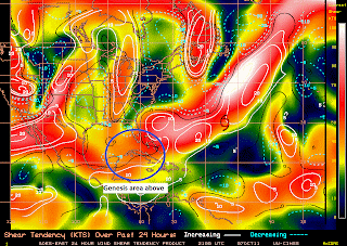
The shear tendency is showing an increasing profile as well, adding 5 to 10 knots of shear to the south of Cuba.
The current satellite morphed visible and infrared images from this evening, (10.7.11)
So I have to pick one solution and I pick the ECMWF (European model) as it carries a weak upper low that washes out into a trough early Wednesday. The reason I have to pick is because of the incredible amount of media attention that the possibility of something forming has made it so I have to make a forecast that I particularly don't like for the above reasons. I have never seen a system form or read any research that has ever developed a tropical system with over 10 to 15 knots of shearing in the environment.
If this does develop the impacts are going to limited to some heavy rains over the Florida Peninsula, some fresh winds of around 25 to 30 knots offshore through Sunday night along the southern peninsula, and into midday Monday to the north. With 25 to 30 mph winds over the mainland areas. As for the Keys...we going to get dry slotted which means our pops (possibility of precipitation) is likely too high.
This is my take on the current forecast scenario and I can see that it differs greatly from a lot of the other forecasts around the state. You chose then let me know how I did. Really; this will be a good opportunity for my users to critique my work. I promise you that you can't be as hard on me as I am on myself.
Be ready for some good downpours and breezy conditions, with some possible flooding in low lying and poor drainage areas where flooding normally occurs.
BC


No comments:
Post a Comment