Monday, May 28, 2012

TS Beryl...continued:

Beryl has not performed as anticipated with regard to the forecast track overnight. The model tracks in my opinion, are a little aggressive with the northeast turn of Beryl. Getting into the analysis this morning outside the storm I think the system will head further west before making the turn on Wednesday. It may even dip southwestward and emerge over the northern Gulf of Mexico this afternoon before a trough from the west finally moves the ridge to the north out of the way. Looking at the 300 hPa analysis it is obvious that the upper level winds are out of the north just outside the storm.
Storm Prediction Center Analysis 
The same winds are observed on the 500 hPa layer.
Storm Prediction Center Analysis
And the 850 hPa surface which with the weakness of Beryl may be a decent look at the steering winds. Also the trough can easily been seen over east Texas as it treks across the southern United States. 
Storm Prediction Center Analysis
Beryl is still carried as a tropical storm with winds around 45 knots, mainly in the deep convection on the eastern edge of the storm this morning. The following images are from satellite interrogation, and from the JAX radar. The Tallahassee radar site is not operational this morning. These images are from SimuAWIPS, an online AWIPS tool not from NWS.


 If Beryl taps into the moisture from the Gulf of Mexico the rainfall estimates may be slightly underdone, and the storm may go through a brief period of minimal intensification before the trough impacts the track and puts Beryl back on the forecast Wednesday. It is highly unlikely that Beryl will be anything more than a TS with winds more than we are finding this morning. Beryl is impressive in that the circulation is in tact and the deep layer organization is holding together over land. The western edge of the storm appears to be weaker only due to the radar depiction. With the Tallahassee radar out of service, we can look at the Moody radar and see that there clearly is more reflectivity showing on the western edge of the circulation. (below)
 Be ready and be prepared and go to your local National Weather Service Office web site for Hurricane Local Statements, watches and warnings; http://www.weather.gov/. The weather.gov web site is a clickable site which you can click on your location and it will take you to your local office. Go to the National Weather Service National Hurricane Center web site for the only authority and only official hurricane forecasts and advisories http://www.nhc.noaa.gov/

Cheers,
BC

Sunday, May 27, 2012

Tropical Storm Beryl:


The visible satellite image says a great deal about the accuracy of forecast by the National Hurricane Center. # days ago we had a meandering system that was not truly tropical with a large amount of environmental shear aloft in a somewhat extra tropical mode. The forecast was for and consolidation of the system into a tropical storm as the associated trough lifted out to the northeast. Then a ridge building across New England would drive the system southwestward toward the Georgia / Florida coast. Obviously this was a very good forecast and on a storm that had no clear cut motion when it was started. 15 years ago this would have been a much more unclear forecast event than currently which reflects well on the professionalism at NHC.

As for Beryl, the storm is acting as it should be with verified surface winds gusting to 45 to 50 know at the Sea Buoy 41012 http://www.ndbc.noaa.gov/station_page.php?station=41012


5-day plot - Wind DirectionWind Direction (WDIR):N ( 350 deg true )
5-day plot - Wind SpeedWind Speed (WSPD):36.9 kts
5-day plot - Wind GustWind Gust (GST):46.6 kts
5-day plot - Atmospheric PressureAtmospheric Pressure (PRES):29.55 in
5-day plot - Pressure TendencyPressure Tendency (PTDY):-0.12 in ( Falling Rapidly )
5-day plot - Air TemperatureAir Temperature (ATMP):75.2 °F
5-day plot - Water TemperatureWater Temperature (WTMP):77.7 °F
5-day plot - Dew PointDew Point (DEWP):70.9 °F


The storm has a very good circulation with not much convection surrounding the core. The satellite loop is still impressive and there are tropical storm warnings along the coast from Volusia Brevard county line to Edisto Beach South Carolina. http://www.ssd.noaa.gov/PS/TROP/floaters/02L/java-vis-long.html
Beryl will likely move onto the Florida coast near St. Augustine tonight then emerge off the Carolina coast near Cape Fear or Myrtle Beach Wednesday morning due to a weak trough crossing the eastern United States and a ridge building over the western Atlantic. Beryl will then increase forward motion toward the northeast and out to sea. During this time it is likely Beryl will transition into an extra tropical storm.

The limited convection surrounding the core is a good thing for rainfall estimates that are holding around 3 to 6 inches associated with the land falling storm. The link below is to the Jacksonville Florida radar, KJAX.
http://radar.weather.gov/ridge/radar.php?rid=JAX&product=N0R&overlay=11101111&loop=yes

I do not want to minimize the impacts of Beryl on the area and since these are rarely occurring events in the Jacksonville area I have little basis for suggestions on how to react. For this reason the best source for information is to view you local National Weather Service Weather Forecast Office for their hurricane local statements. These would be the following offices and links to each home page as follows:
Melbourne, Florida http://www.srh.noaa.gov/mlb/
and the hurricane local statement: http://forecast.weather.gov/product.php?site=NWS&issuedby=MLB&product=HLS&format=CI&version=1&glossary=0
Jacksonville, Florida: http://www.srh.noaa.gov/jax/
and the video hurricane local statement:  http://www.srh.noaa.gov/media/jax/vBriefing/Beryl_Web_Briefing_052716_7h/index.htm
Charleston, South Carolina: http://forecast.weather.gov/product.php?site=NWS&issuedby=CHS&product=HLS&format=CI&version=1&glossary=1

It looks like the impacts from Beryl will be typical of a weak, slow moving Tropical Storm with ample rainfall, winds between 40 to 65 mph, flooding, and power outages. Do not minimize your response and be safe. The official authority for hurricane forecasts, watches and warnings is the National Weather Service, National Hurricane Center, and your local National Weather Service Weather Forecast Office.
http://www.nhc.noaa.gov/
http://www.weather.gov/

Be safe,
BC

Friday, May 25, 2012

Sub-Tropical Storm Beryl:

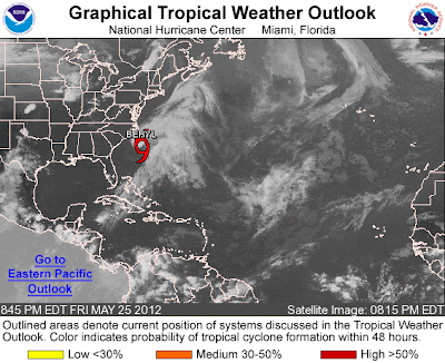
Lets hope that this is not a harbinger of the season to come. The second pseudo-tropical system of the year and we are still 7 days ahead of the beginning of the official start of hurricane season 2012. Beryl is a complex system with a nice low level center which has had some substantial pressure falls this evening. There is still a large amount of shear aloft in the upper level of the environment. The first image is of the pressure anomalies in the Western Atlantic and the second is of the latest satellite image of Beryl.


 The storm looks a lot like a cold core low with a frontal zone east extending out of the upper low. The graphic below shows the amplitude of the shear.
Then we can see the upper level shear values in the wind field below.

The tropical precipitable water loop found at http://tropic.ssec.wisc.edu/real-time/mimic-tpw/natl/main.html
shows the dry air to the west, and east of the frontal zone, with high values flow northward through this area and into the low. Typical of a non tropical low this system has a comma shape to it.
There is an upper low trekking across southern Canada heading for the Maritimes and will produce a trough fracture north of Beryl trapping the low south of a building ridge cross New England. Due to this ridge Beryl will slide southwestward toward the South Carolina, Georgia, and Florida coasts most likely by Sunday.
As Beryl makes landfall somewhere in the watch / warning area expect  ample amounts of rainfall and high seas. There will be an amplifying trough and ridge system moving across the eastern United States Tuesday that should pick the storm up and move a much weakened Beryl back out to sea. 

Please pay attention to your local Weather Forecast Offices watches and warnings, along with the National Hurricane Center advisories. Go to http://www.weather.gov/ for a point and click map that will take you to you local office web page. It will look like the following image. 
Be safe!

Wednesday, May 23, 2012

There has certainly been some early development in the Atlantic so far this season. As usual with these early season vorticies, they have been unimpressive. Invest AL94 is extremely unlikely that there will be any development of this as a tropical system. The surface circulation is devoid of convection due to the large scale shear of at least 50 knots over the area. There is a large scale trough crossing the eastern Gulf of Mexico, and the amount of dry air in the column will subdue even the cloud line showers that try to break through the cap along the Keys Island Chain.
Visible Satellite image of suspect area
A look at water vapor imagery shows a distinct gradient between the dry air west and moist column east of the circulation.
Water vapor image from GOES East
Closer view of the vapor imagery

As usual too, the only official authority for hurricane forecasts, watches and warnings are the National Hurricane Center,  http://www.nhc.noaa.gov/, and your local National Weather Service Office, http://www.weather.gov/.
I will keep you updated as schedule and conditions dictate.
Be safe and be prepared.
BC

Saturday, May 19, 2012

The first tropical storm of the year has made an early appearance. Alberto is the first storm of the 2012 season and as would be expected, not very impressive. The proximity to land, and the uncertainty in the track forecast
has prompted issuing advisories on this system.
At 5:00 PM EDT the center of tropical storm Alberto was located about 140 miles east southeast of Charleston SC near latitude 32.2 north...longitude 77.7 west.
Image courtesy of NOAA National Hurricane Center
http://www.ssd.noaa.gov/PS/TROP/floaters/93L/93L_floater.html
Alberto is moving to the southwest near 3 mph and is expected to continue this motion through Sunday with a turn toward the west northwest then north to northeast through Monday. 

Maximum sustained winds are near 45 mph with higher gusts. There may be some strengthening over the next few days. Tropical storm force winds extend outward up to 45 miles from the center. The estimated minimum central pressure is 1007 mb, or 29.74 inches of Hg. Expect an update from the Hurricane Center at 11:00 PM. 
There seemed to be plenty of debate on whether to start this storm or not. The satellite presentation is quite good on visible but the convection is much more active on the southern edge of the storm. All indications are for a typical early season storm in that strengthening will be limited. The track forecast is extremely uncertain for several reasons including the lack of initial motion, and the size of the storm is small enough to fit within the grid so model initialization will be difficult. Main issues with this system would be rainfall along the Carolina's, especially along the Coastal Plain, and winds and seas for marine interests. We now know that Myrtle Beach is out of the woods. Jim Cantore is on his way there which means the storm isn't. :-)

I was going to work on a preseason get working on your hurricane kit blog post next week. So here it is a week early. Make sure you have your hurricane and severe weather kits ready and updated with your current information, accounts, records, documents, prescriptions, and your digital inventory. For more information visit http://www.nhc.noaa.gov/prepare/
for more information. Get your NOAA All Hazards Weather Radio out and make sure its programmed correctly. Just because you don't live in a hurricane prone area does not mean you can not be impacted by the storm. Weak tropical storms that move slowly can cause incredible inland flooding similar to what Hurricane Camille in 1969 was a deadly storm when it made landfall. 

The storm moved northeastward very slowly and hung up over the Appalachian Mountains over western Virginia and northern Carolina's while dumping immense amounts of rainfall across the mountains causing an historical flood of the 100 to 500 year variety. This means a flood that occurs once every 100 to 500 years. 

A lot of people say that we will haven't been hit for a long time so we are okay. Don't fall into to this group! Be prepared for the worst case and then you will not have to panic with all those other folks that think they are immune to weather. 
As always the ONLY OFFICIAL AUTHORITY FOR HURRICANE FORECASTING, WATCHES AND WARNINGS IS THE NATIONAL HURRICANE CENTER AND YOU LOCAL NATIONAL WEATHER SERVICE, WEATHER FORECAST OFFICE. http://www.nhc.noaa.gov/