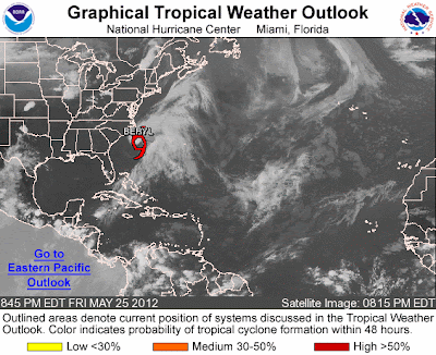
Lets hope that this is not a harbinger of the season to come. The second pseudo-tropical system of the year and we are still 7 days ahead of the beginning of the official start of hurricane season 2012. Beryl is a complex system with a nice low level center which has had some substantial pressure falls this evening. There is still a large amount of shear aloft in the upper level of the environment. The first image is of the pressure anomalies in the Western Atlantic and the second is of the latest satellite image of Beryl.
Then we can see the upper level shear values in the wind field below.
The tropical precipitable water loop found at http://tropic.ssec.wisc.edu/real-time/mimic-tpw/natl/main.html
shows the dry air to the west, and east of the frontal zone, with high values flow northward through this area and into the low. Typical of a non tropical low this system has a comma shape to it.
There is an upper low trekking across southern Canada heading for the Maritimes and will produce a trough fracture north of Beryl trapping the low south of a building ridge cross New England. Due to this ridge Beryl will slide southwestward toward the South Carolina, Georgia, and Florida coasts most likely by Sunday.
As Beryl makes landfall somewhere in the watch / warning area expect ample amounts of rainfall and high seas. There will be an amplifying trough and ridge system moving across the eastern United States Tuesday that should pick the storm up and move a much weakened Beryl back out to sea.
Please pay attention to your local Weather Forecast Offices watches and warnings, along with the National Hurricane Center advisories. Go to http://www.weather.gov/ for a point and click map that will take you to you local office web page. It will look like the following image.
Be safe!


No comments:
Post a Comment