At 5:00 PM EDT the center of tropical storm Alberto was located about 140 miles east southeast of Charleston SC near latitude 32.2 north...longitude 77.7 west.
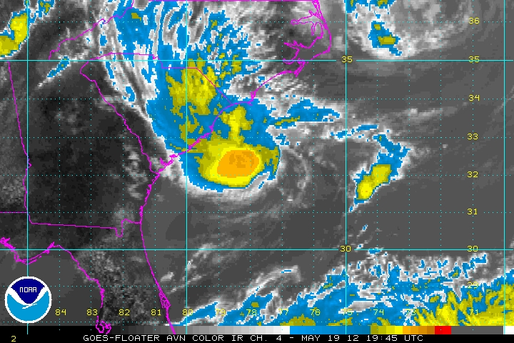 |
| Image courtesy of NOAA National Hurricane Center http://www.ssd.noaa.gov/PS/TROP/floaters/93L/93L_floater.html |
Alberto is moving to the southwest near 3 mph and is expected to continue this motion through Sunday with a turn toward the west northwest then north to northeast through Monday.

Maximum sustained winds are near 45 mph with higher gusts. There may be some strengthening over the next few days. Tropical storm force winds extend outward up to 45 miles from the center. The estimated minimum central pressure is 1007 mb, or 29.74 inches of Hg. Expect an update from the Hurricane Center at 11:00 PM.
There seemed to be plenty of debate on whether to start this storm or not. The satellite presentation is quite good on visible but the convection is much more active on the southern edge of the storm. All indications are for a typical early season storm in that strengthening will be limited. The track forecast is extremely uncertain for several reasons including the lack of initial motion, and the size of the storm is small enough to fit within the grid so model initialization will be difficult. Main issues with this system would be rainfall along the Carolina's, especially along the Coastal Plain, and winds and seas for marine interests. We now know that Myrtle Beach is out of the woods. Jim Cantore is on his way there which means the storm isn't. :-)
I was going to work on a preseason get working on your hurricane kit blog post next week. So here it is a week early. Make sure you have your hurricane and severe weather kits ready and updated with your current information, accounts, records, documents, prescriptions, and your digital inventory. For more information visit http://www.nhc.noaa.gov/prepare/
for more information. Get your NOAA All Hazards Weather Radio out and make sure its programmed correctly. Just because you don't live in a hurricane prone area does not mean you can not be impacted by the storm. Weak tropical storms that move slowly can cause incredible inland flooding similar to what Hurricane Camille in 1969 was a deadly storm when it made landfall.

The storm moved northeastward very slowly and hung up over the Appalachian Mountains over western Virginia and northern Carolina's while dumping immense amounts of rainfall across the mountains causing an historical flood of the 100 to 500 year variety. This means a flood that occurs once every 100 to 500 years.
A lot of people say that we will haven't been hit for a long time so we are okay. Don't fall into to this group! Be prepared for the worst case and then you will not have to panic with all those other folks that think they are immune to weather.
As always the ONLY OFFICIAL AUTHORITY FOR HURRICANE FORECASTING, WATCHES AND WARNINGS IS THE NATIONAL HURRICANE CENTER AND YOU LOCAL NATIONAL WEATHER SERVICE, WEATHER FORECAST OFFICE. http://www.nhc.noaa.gov/
No comments:
Post a Comment