Thursday, September 6, 2012

Track for Leslie behaves well. Updated

The forecast track this evening is more to the east again:

The latest track forecast continues the eastward shift due to the trough over New England picking up the upper level low east of the FL/GA coast. This low will slowly move northeast while blocking the path of Leslie, and moving the path to the east. A loop of the water vapor imagery clearly shows the trough moving the upper low. http://www.goes.noaa.gov/HURRLOOPS/huwvloop.html
Will keep this post short but it is good news for Bermuda.
Here is what the storm looks like...
You'll notice the bulk of the vigorous convection on the northern and eastern quadrants of the storm. The last graphic will show the forecast track of the storm.

Wednesday, September 5, 2012

Leslie future track is further east

The National Hurricane Center NHC has upgraded Leslie to hurricane status this afternoon. From the satellite presentation and Oceansat-2 winds I think this is a prudent assesment of the strength in the core of Leslie. 
On the wider view of the Oceansat data we see a very good circulation that is tilted eastward with the strongest winds over the northeast quadrant. Unfortunately NOAA and the Air Force Hurricane Hunter Aircraft are not flying into the storm. NASA is sending a Global Hawk over the storm tomorrow which may reveal the upper flow patterns and more about the tilt of Leslie, providing additional information for the models. This could help to pin down the track even more. A closer view of the Oceansat data (below) shows 65 knots from satellite derived winds near the center of circulation just northeast of the center. 
The visible satellite view shows a slightly better organization to the storm today.
The track has shifted to the east as mentioned above, although possibly due more to the upper low northeast of Bermuda than the trough moving across the New England Coast.
There is some developing wind shear to the west of Bermuda with a COL region (region of little winds and wind shear) to the north of Bermuda. 

While the change in track isn't great news for Bermuda, it is better news. If the track continues the shift to the right I would expect the impacts will be less due to the stronger winds in eastern semicircle. Everyone I know, not many, in Bermuda are prepared and waiting. 
Be Safe!
BC

Monday, September 3, 2012

Leslie looking better today.

The satellite presentation from Leslie looks much different than 24 hours ago. From visible satellite loops earlier in the day, the center circulation started out exposed from the vigorous convection to the south and east. Latest satellite interrogation shows the convection is wrapping around the circulation again late this afternoon. This likely signifies a storm at least better better organized. Also think this may induce a period of intensification for several reasons. Here is a look at Leslie 
The ripples near the brightest white are gravity waves propagating outward from the deep convective burst. This image is a little old, couple of hours, but shows the convection engulfing the center of circulation. The image below shows how intense the convection really is with -80 Celsius and colder cloud tops. 
The forecast track has shifted ever so slightly to the west likely due to the forecast models as we haven't really had any trends to follow for the last day or two. The forecast will likely change over the next few cycles as the storm gets its act together so this is not hard and fast yet. My thoughts are if the storm moves west of Bermuda this places the Island in the higher risk area of Leslie. The right front quadrant has statistically the highest winds, more likely to have tornadoes, and greatest storm tides/surge. Recent Oceansat 2 satellite pass shows the winds around Leslie quite well.
The winds are highest on the east side of the storm which reinforces the idea of the right front quadrant as the most potent area of the storm. Another reason that Leslie may intensify is that the shearing around the storm has relaxed, as has the shear tendency.

The NHC wind probabilities indicate that the chance of Leslie reaching hurricane strength is about 50%. Again I think that this may change sometime through the next few forecast cycles due to the more favorable environment around the storm, and better storm-centric  organization. 
The next few graphics show the numerical probabilities, and updated Tropical Storm/Hurricane force winds graphics. 


For my friends in Bermuda, the best advice I can offer is to be prepared. Speak with people that have been there a long time as they will have local experience that will prove invaluable. The folks along New England should be keep a watchful eye on Leslie just in case. I do think the models, especially the GFS...Global Forecast System...have a good handle on the track after 5 days taking the storm, northward, then northeastward with the greatest impact to the Canadian Maritimes before heading out to the North Atlantic. 
I will keep an eye on this one. Leslie is at least proving interesting from a forecasters point of view. Last note...surfers along the Eastern Seaboard, and the boarder islands between the Caribbean and Atlantic are going to have great surf. 
Be safe,
BC 

Sunday, September 2, 2012

Leslie hangs in, Friday's comin!

'Leslie keeps chugging away even though the environment surrounding the system is quite hostile, and the storm itself is rather disorganized. A look at satellite shows some convection near the center of the circulation, but not surrounding it. All images with a few exceptions are from CIMSS: Cooperative Institute for Meteorological Satellite Studies
Space Science and Engineering Center  /  University of Wisconsin-Madison
From the image above we see the "one sided" appearance with most of the convection held to the southern hemisphere of Leslie. The reason for this is the shear in the environment around the storm. The next several images will help describe this better than words. 
First the shearing environment, 
Notice the shear values on the northeast and west quadrants between 40 and 50 knots. The shear tendency is increasing as well in these areas.
To verify this we have several polar orbiting satellites with good passe near the storm, first the Oceansat-2 (OSCAT) observations, followed by the Advanced Scatterometer, (ASCAT)
Notice the higher winds on the east semicircle indicating the shear to the east. Looking further out from Leslie we find the mechanisms responsible for the slow and indecisive motion of the storm during the past 24 hours or so.

Total winds show the upper level low parked over the Bahamas which has begun to retrograde to the west. A trough across the southeast is pushing toward the northern Gulf of Mexico, and a mesoscale ridge is stalled over the northeastern Gulf. A better look at the upper levels only reveals the low very well.
So where is Leslie going? Not very far very fast. Plus the environment may become less hostile for redevelopment late in the forecast. From CIMSS:
From NHC the official forecast which is easier to look at but I like the display from CIMSS better:
The forecast beyond this time frame is uncertain but I am certain that some sources in the media will be touting the future of the storm and the model output. So to soften this I will show you the extended models in the order of the (GFS) Global Forecast System, (ECMWF) European Medium Range Forecast, and the (CMC) Environment Canada models. Environment Canada has proven to be the intensification model of choice. 

All show some significant intensification after 5 days while picking up forward speed and heading for the Canadian Maritimes. This we will have to wait for. The model errors are significantly higher in the extended time periods of the forecast.
Be well,
BC

Friday, August 31, 2012

Leslie

Good evening all,

Thought after the past week that there may be some curiosity about Leslie in the Atlantic. 
Now that I am finally back with the living and mostly rested after the bought with Isaac and a long line of long shifts, I should put something out about the tropics, good and bad, but not so bad. 
First graphic is the future track for Leslie and this system should remain out in the central Atlantic. There may be some action for Bermuda but mostly a fish storm. (The not so bad)
Thanks to CIMSS  Cooperative Institute for Meteorological Satellite Studies
Space Science and Engineering Center  /  University of Wisconsin-Madison 

The good is that behind Leslie a plume of dust from the Saharan Air Layer (SAL) is moving off the African coast and will be crossing the central Atlantic. This should subdue any development at least for the next week. 
Thanks to CIMSS  Cooperative Institute for Meteorological Satellite Studies
Space Science and Engineering Center  /  University of Wisconsin-Madison 

That's all I have for now. I hope all my friends along the Northern Gulf of Mexico have made it through Isaac unscathed, or with as little problem as possible. 
BC

Monday, August 27, 2012

Isaac heading for the Delta !UPDATE! 6AM

After heading home early I woke and saw that there appears to be an eye wall forming on Isaac south of the Mouth of the Mississippi. The first rain bands are wrapping along the coast as well. 

The storm may be undergoing some RI (rapid intensification) due to dry air to the north wrapping into the center. the proximity to landfall should limit the degree of strengthening. 

All my friends along the northern Gulf Coast should have completed preparations. Especially those that live in coastal communities, even as far east as the Big Bend of Florida. The storm surge will be fairly significant as Isaac makes landfall and the wave action will likely cause erosion to the beaches, and in the usual places along Highway 98 across the Florida Panhandle and coastal Alabama. Lets address the numbers on Isaac first, at 11 pm Isaac was located about 190 miles southeast of the entrance of the Mississippi River. The storm is moving northwest (310) degrees near 10 mph, and maximum sustained winds are 70 mph with gusts 75 to 80 mph, using a 1.2 to 1.4 gust factor. 

Below is a list of Watches and Warnings from the last NHC advisory.
The storm surge may be the highest risk to life and property as Isaac makes landfall. The following links are for Storm Surge Exceedance, neaning above the National Geodetic Vertical Datum, not mean sea level. Then the Storm Surge Probabilities, based on the same datum. 

The track of Isaac has held fairly steady since passing just south and west of Key West last night, likely between the Marquesas Keys and the Dry Tortugas National Park around 6 pm with a minimum pressure of 997.3 at the Key West International Airport. 
The storm has been gradually intensifying during the day and is nearing category one strength. Isaac has been churning over the Gulf of Mexico for a couple of days as indicated by the seas, buoy 42003 west of Ft. Myers has measured seas around 17 feet. The forecast is for a moderate category one hurricane at landfall with 80 mph sustained and up to 100 mph gusts. 
The above is a chart of the hurricane wind speed probabilities. You will notice that the likelihood of anything stronger than category one is at the highest value, 16 percent. 

This is a much weaker storm than Katrina, but should not be underestimated. The storm winds after passage away from Key West were higher than as the storm passed south of the island. The wind field is quite large as was seen with the winds from Northern Broward county through St. Lucie Counties along the east coast of Florida last night. Please be Weather Ready, and be safe. For current watches and warnings along with the fastest updates go to your National Hurricane Center website, and for local warnings, hurricane local statements,  and preparedness guides, go to your local National Weather Service web page at the point and click site. Also remember, your best source for weather information on the web ends with .gov not .com. :-) My last midnight shift for 5 weeks with a couple of extras thrown in for fun, I am ready for sleep. Will update tomorrow if I wake up in time for the land falling event. 
Let me know how the storm has impacted you through the comments section of the blog. 
Cheers,
Bill

Sunday, August 26, 2012

Issac passes Key West.

It was a typical tropical storm event for Key West today with some really good winds, some decent rains, lots of palm frond's in the street. Some tidal flooding due to bands pushing water up onto the south side of the islands. Very little damage reported so far. 
As of 11 pm Issac was about 75 miles west of Key West near the Dry Tortugas National Park. 
Maximum winds from the Hurricane Hunter aircraft was 55 knots and Issac was heading west-northwest near 14 mph. Issac should slow its forward sped a bit and gain some strength as it bears down on the Gulf Coast of Louisiana / Mississippi. The maximum in the intensity forecast  is for a moderate to high category one hurricane before landfall. my experience with the Lower Mississippi River Forecast Center, National Weather Service WFO Slidell, and the Corps of Engineers, is that they are the best in the business. While working in Ft. Worth during the floods of 2011 I believe the City of New Orleans, and the State of Louisiana will keep their communities safe with Issac. 

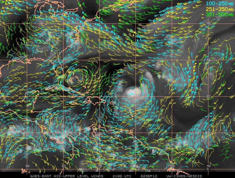
The NHC track is slowly shifting west again:
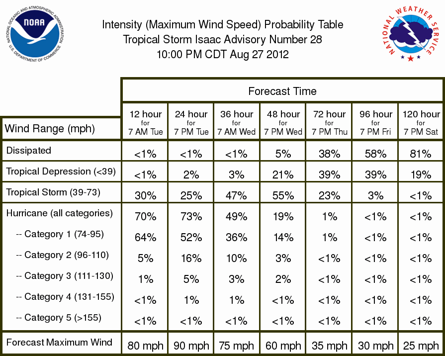
The wind probabilities form NHC:
Keep checking your local National Weather Service Office website for hurricane local statements that will have information on closings, shelters, and evacuations in your area. 
I'm ready for this one to end now thank you very much!